

- News
- Science News
- Earth “rang like a bell” for 9 days: Scientists trace the eerie signal to a Greenland megatsunami
AA
Text Size
- Small
- Medium
- Large
1/7
Earth “rang like a bell” for 9 days: Scientists trace the eerie signal to a Greenland megatsunami
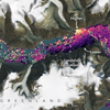
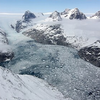
In September 2023, a colossal landslide in Greenland’s Dickson Fjord triggered a megatsunami, causing the entire planet to vibrate every 90 seconds for nine days. An unprecedented seismic hum was detected worldwide. Satellites have now unveiled the cause: resonant fjord oscillations.
A 25.5 million cubic metre rockslide, driven by climate change-induced glacial melt, plunged into the 540-metre-deep fjord, spawning a 200-metre tsunami wave. This initiated prolonged water sloshing, akin to a vast bathtub, with the fjord’s narrow confines amplifying the effect.
Credit: National Geographic
2/7
What was the trigger of the megatsunami
According to a study published in Nature Communications, the scientists soon linked the signal to Greenland’s Dickson Fjord, a narrow inlet hemmed in by 3,000-foot cliffs on each side. A 25.5 million cubic metre rockslide, triggered by climate change-driven glacial melting, crashed into the 540-metre-deep fjord, generating a 200-metre tsunami. This sparked extended water sloshing, like a giant bathtub, intensified by the fjord’s narrow walls.
Credit: Wikipedia
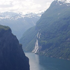
3/7
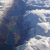
Where is Dickson Fjord located
Dickson Fjord is in the northernmost area of the King Oscar Fjord system. It is the biggest branch of Kempe Fjord. Its mouth opens on the northern side at the western end of the fjord, where there is a junction of three branches, the other two being Röhss Fjord and Rhedin Fjord.
Credit: Wikipedia
4/7
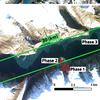
Satellites reveal “Fjord resonance”
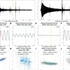
Copernicus Sentinel-2 and NASA’s Surface Water Ocean Topography satellite, known as SWOT imagery, exposed the mountainside scar and distant wave traces, confirming a 90-second seiche, a standing wave matching global signals. This persistent resonance transferred energy to Earth’s crust, highlighting the risks of Arctic landslides amid warming.
According to Nature Communications:
The seismic observations of September and October very-long-period (VLP) signals.
ALE Seismic Station and Surface Water Ocean Topography mission (SWOT) cross-channel slopes.
Credit: Nature Communications
5/7
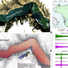
Scientists unveil crustal heartbeat
Seismic stations typically capture erratic scribbles during earthquakes. Here, traces showed smooth peaks, 90 seconds apart, persisting nearly two weeks with little decay.
No seiche had ever generated such enduring global signals. One model estimated 2.6-metre sloshes; another 7–9 metres. Discrepancies arose from Dickson Fjord’s geometry assumptions, yet both pinpointed the landslide-spawned wave. Simulating this prolonged, sloshing tsunami proved a major challenge,” said Alice Gabriel of UC San Diego’s Scripps Institution of Oceanography.
Credit: NASA
6/7
History of Dickson Fjord
Swedish Arctic explorer Alfred Gabriel Nathorst first surveyed Dickson Fjord in 1899 during the Swedish Greenland Expedition, seeking survivors of S. A. Andrée’s 1897 Arctic balloon venture. He named it after financier Robert Dickson (1843–1924). In 1930, the Norwegian vessel Veslekari reached its head, measuring 568.75 m in depth.
Credit: Wikipedia
7/7
Warming climate, melting glaciers
Glacier ice formerly stabilised the precarious slope, but warming air and sea have eroded this buttress.“Climate change alters Earth’s norms, unleashing atypical events,” observed Gabriel.
Comparable instability in Karrat Fjord (2017) spawned a fatal tsunami, razing eleven homes and claiming four lives. Dickson Fjord lies by a key cruise path. Though empty in 2023, surging Arctic tourism amplifies threats. Officials now eye early-warning systems merging satellite and seismic feeds.
Credit: Wikipedia
Follow Us On Social Media