


Maps sit quietly in classrooms, on news websites and inside phone screens. They look settled and precise, but the world they show is always slightly bent out of shape. Because the Earth is round, any flat world map must stretch or compress something. Over time, certain projections have become familiar, especially the Mercator projection. Critics have long argued that this repeated exposure may alter how people imagine the size of continents and countries. A large international study, “The Influence of Map Projections on People’s Global-Scale Cognitive Map: A Worldwide Study”, published on MDPI, set out to examine that concern in measurable terms. Researchers collected responses from more than 130,000 participants and compared their size estimates with different map projections and with real globe proportions. The findings add weight to an ongoing debate in cartography and cognitive science.
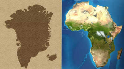
Mercator projection makes Greenland appear larger than Africa on the maps
On a globe, the difference is clear. Africa’s landmass stretches across the equator and into both hemispheres. Greenland sits much farther north and occupies a fraction of the space. Africa is around fourteen times larger than Greenland. This is not a marginal discrepancy. It reflects basic geographic measurement. The confusion begins only when the curved Earth is flattened for display. The visual imbalance is closely linked to the Mercator projection, created in the sixteenth century for navigation. The design preserves angles, which helped sailors plot straight routes. It does not preserve area.As latitude increases, land appears stretched vertically and horizontally. Greenland lies near the Arctic Circle, so it expands dramatically on this projection. Africa, much of which lies near the equator, remains closer to its true scale. The result feels persuasive because the distortion is systematic. It affects all high-latitude regions, not just Greenland.
Flat maps cannot show a round Earth without distortion
Any flat world map must compromise. Some projections protect the area. Others protect shape or direction. None can maintain every property at once. Equal-area projections reduce the Greenland effect, though they alter shapes in other ways. Globe-based digital maps have become more common, yet the familiar flat world map remains widely used in media and education. The issue is not deception. It is geometry.
Size bias shapes perception more than projection
What did stand out was a familiar psychological pattern. Smaller countries were often overestimated. Larger ones were underestimated. This relationship was strong across reference cases, including Japan, South Africa and the United States.Researchers noted that this bias corresponds with established psychophysical principles. Human judgement does not scale evenly with physical size. That tendency appears more influential than exposure to a specific map style.
Familiarity with projections shows limited impact
Participants were also asked which projection they knew best, including the Robinson projection and the Gall–Peters projection. Familiarity did not translate into more distorted estimates.The broader picture suggests that global cognitive maps are shaped by mixed experiences rather than by one dominant cartographic image. The distortions remain on paper. In the mind, they soften.